)
)
)
)
 into the bank of the dike to stop the current causing further erosion. These (information missing) planks are driven in and wired firmly to a log on land side of the dike. Ear(information missing) on to the log to give firm anchorage.
WATER ERODES THE BANK – This is a view of the erosion caused through the water wearing the soil of the dike east of Poplar Point. The plank from the land to the river weighed down with sandbags is to stop the planks which have been laid edge-on from floating with any rise of the river level.")
Tashiro May 13/55 News ASSINIBOINE RIVER FLOOD DIKE CONDITIONS & REINFORCEMENTS EIGHT MILES EAST OF POPLER POINT
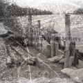
DIKING in progress east of Poplar Point. Ray Proctor of Woodlands operates a bulldozer for the provincial department of works, strengthening the dike nine miles east of Poplar Point. The earth to do this work is being dragged off the old No. 1 Highway. These sandbags are to be salvaged for use in another part of the dike.
BARRICADE built against the wash of the river east of Poplar Point. This (information missing) into the bank of the dike to stop the current causing further erosion. These (information missing) planks are driven in and wired firmly to a log on land side of the dike. Ear(information missing) on to the log to give firm anchorage.
WATER ERODES THE BANK – This is a view of the erosion caused through the water wearing the soil of the dike east of Poplar Point. The plank from the land to the river weighed down with sandbags is to stop the planks which have been laid edge-on from floating with any rise of the river level.

- Posted on
- Wednesday 1 June 2016
- Dimensions
- 5315*4186
- File
- 11044b.jpg
- Filesize
- 2909 KB
- Albums
- Visits
- 988
- Rating score
- no rating
- Rate this photo
0 comments