The Oxbow Woods self-guided interpretive trail was initiated in 1994 as part of a work term project, Environmental Science Program, University of Manitoba. The objective of the project was to create a low-impact, self-guided interpretive trail through the major ecoregions of Oxbow Woods. The information provided here will be useful for naturalists, small educational groups, summer field courses, undergraduate students and researchers.
Oxbow Woods is a large, relatively undisturbed gallery forest adjacent to an abandoned channel of the Assiniboine River. The forest, which is comprised of many different communities, is for the most part dominated by plant species characteristic of the deciduous forests of eastern North America. The river bottom or 'gallery' forests of Manitoba are unique in Canada, but most have been destroyed or severely disturbed. These forests were first prized for their high quality fire wood, and for building material. Many of the gallery forests in Manitoba have since been cleared for agriculture, and more recently for settlement (riverside lots are increasingly popular for their scenic and aesthetic value). Where gallery forests remain, the understory has often been modified from excessive trampling and other anthropogenic disturbances, and the introduction of Eurasian invasive species. Oxbow Woods is a large, undisturbed remnant gallery forest south-west of the hamlet of Delta, Manitoba.
The trail has been designed to have minimal impact on Oxbow Woods, while at the same time making the forest accessible to patrons of the University of Manitoba Field Station. Please bear the following in mind when using the trail:
If these suggestions are followed, the natural state of the forest should be maintained for future generations.
Above all, enjoy your walk through the forest. Consider it a privilege to be able to visit this beautiful and unique ecosystem.
Manitoba was covered by an ice sheet up to 10,500 years ago. The processes after the retreat of the glacier in the post glacial times have formed the area to what you can see now. Lake Manitoba, like Lake Winnipeg and the other 'Manitoba great lakes', is a remnant of post-glacial Lake Agassiz. This lake formed after the ice sheet retreated northwards, draining melt waters into the southern basin. Lake Agassiz drained as the glacier retreated, opening the lower outlet of Fairford River. Approximately 9,500 years ago the area was flooded again by Lake Agassiz II after the ice re-advanced southward and plugged the Fairford River outlet. At this time the water level rose over 80 m. Lake Agassiz drained again as eastern outlets were opened.
The Assiniboine River began to drain into Lake Manitoba 4,500 years ago. This was the time when the sand of today's ridge (located between the southern lakeshore and the Delta Marsh) and the sediments of Oxbow Woods were deposited. About 3,000 years ago the Assiniboine River stopped draining into Lake Manitoba, but the water-level of the lake has remained relatively constant since the climate became wetter and cooler.
Prairie gallery forests develop on eroded river sediments. Prairie rivers are continually changing their course, eroding their sediments on the outside of a meander while depositing material on the inside. These accumulated nutrient-rich sediments provide a substrate for vegetation colonization. The first woody species to colonize on the moist sediments are willows and cottonwood. This vegetation stabilizes the substrate and allows later successional species to establish and grow.
Today you still can see remnants of the river that once flowed through this area. The old river-bed (known locally as the Blind Channel) is at a lower elevation than the surrounding land, and the deposited sediments have been colonized by forest in many areas.
Human occupation in Manitoba began roughly 10,000 BP, at the end of the last ice age. As the glaciers retreated, the glacial lakes dried up, exposing the land and so leading to floristic and faunal colonization. Human occupation in the area is evident from the presence of stone tools, which are scattered along the south beach of Lake Manitoba.
The first large occupation at Delta Marsh was by the 'Oxbow Culture' that existed in Manitoba between 5,300 and 3,000 years ago. Archaeologists have assigned this culture based on the shape of the projectile points (arrowheads) made by these people. The Assiniboine River had changed it's course and was flowing into Lake Manitoba between 4,500 and 3,000 years ago, allowing large populations to move into the area.
The native groups that lived in Manitoba were mainly nomadic hunter-gathers following seasonal rounds. This allowed the people to take part in trade networks, and to hunt and gather food during the most plentiful seasons. These rounds also allowed natives to gather raw materials that they needed to make stone tools, baskets, ceramics and textiles.
Examination of the flora and fauna of the Oxbow Woods region reveals the wealth of natural resources in the area. The most abundant times of the year would be spawning time in the spring, and berry-picking and game hunting in the fall.
The goal of the archaeological work done in 1994 was to determine whether native people were using and occupying the area now known as Oxbow Woods. Test pits were dug in an open meadow to the north of the forest. Few artifacts were recovered, suggesting that this was not a major habitation area. It seems likely that Oxbow Woods was used as a hunting ground, where butchering and minor processing would have occurred. One Knife River Flint flake was recovered from test pit 6. The closest quarry of Knife River Flint is in southern North Dakota, indicating that the people had contact with south either from trade routes or in their seasonal rounds.
The La Verendrye family were the first Europeans to visit the region in the 1730s, but the immediate region was not permanently settled until after 1850. The Inkster family built their original homestead on the west side of the Blind Channel, in the area north-west of the Oxbow Woods. Remnants of this settlement can still be seen today. There was a small native settlement on the east side of the Blind Channel, north of Oxbow Woods. The next generation of Inksters built a successful farm east of the southern portion of Oxbow Woods. Donald Bain purchased the property which became the University Field Station (including the Inkster farm) in the 1920s, building the hunting lodge and outbuildings on the Lake Manitoba shore. The University of Manitoba acquired this property in 1966 for research and teaching purposes. The region was recognized as an Ecologically Significant Area in 1988.
| Aerial photo | This is an image of the forest taken from an infrared aerial photo. The difference between forest and meadow is apparent, as well as the cultivated fields to the east of the channel. Since the forest was partially cleared for cultivation, the banks of the old channels of the river are somewhat visible. |
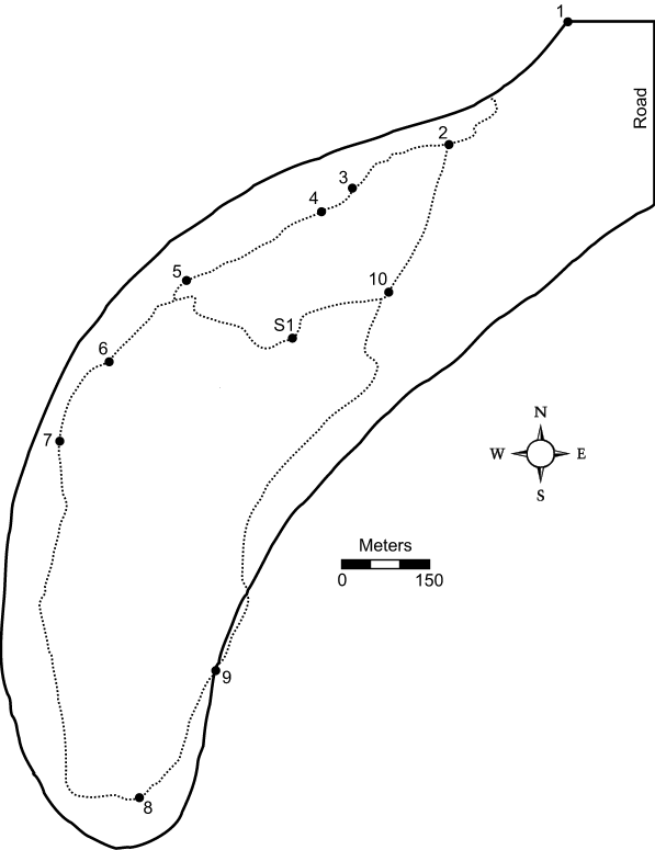
| Trail | This is the map that will be most useful to you when hiking the trail. The interpretive stops are marked. The left turn off at the short trail is marked with an "S" and the long trail continues with blank signs to the right. |
| Vegetation Zones | The major vegetation cover discussed in the interpretive information is outlined on this map. |
The legend shows the code for the different areas.
The stop numbers listed here coincide with the numbers indicated on orange markers along the trail (see Appendix C). Follow the direction of the arrows and the map to navigate, but if in doubt, continue on the most used deer trail.
When you are passing through the different communities, be sure to refer to the vegetation maps and species lists, and take note of the plant and animal species you see.
| Stop 1: | This is the north meadow of the Oxbow forest. It is mainly comprised of snowberry (Symphoricarpos occidentalis), raspberry (Rubus idaeus), thistles (Circium arvense), and a number of grass species. To the west and to the south east are the old channels of the Assiniboine River that are filling in with marsh vegetation (Typha latifolia, Scirpus sp., Phragmites australis). In the spring of 1991, this meadow was accidentally burned in a large marsh fire. Burned, dead trees are apparent in the area. The beautiful yellow lady's slipper (Cypripedium calceolus) is the highlight of this part of the trail in the early summer. |
|---|---|
| Stop 2: | This is the transition zone from meadow to forest. Consequently, there are plant species that are typical to both communities. Tall shrubs (hawthorns, chokecherries, willows) are common in the area. The thatch ant hills are typical of this region. The region is ideal nesting habitat for many bird species, and young deer like to bed down in the tall grass during the day to escape the heat and predators. |
| Stop 3: | The now continuous forest marks the end of the transition zone. Tree species typical of the Oxbow Woods, including green ash (Fraxinus pennsylvanica), bur oak (Quercus macrocarpa) and Manitoba maple (Acer negundo), are common. The larger green ash, and most of the bur oaks, are about 100 years old. The Manitoba maples are not any older than 80 years. The very large tree that is the highlight of this stop is a basswood(Tilia americana). This species, which reaches its northern distributional limit in this forest, is characterized by heart-shaped leaves and a winged fruit. This species, which rarely occurs in pure stands in Manitoba, is locally common along the eastern portions of the Assiniboine River and along the Red River south of Winnipeg. The specimen at this stop along the trail is the only member of this species that we have found in the region. The dominant ground cover species in this area is typified by Aralia nudicalis (wild sarsaparilla) in the spring/early summer, and Rudbeckia laciniata (tall cone flower) and Amphicarpa bractaeata (hog peanut) later in the summer. |
| Stop 4: | The ostrich fern stands (Matteuccia struthiopteris) occur as two large colonies in this portion of open forest. Since these ferns are clonal, these 'stands' may in fact be individual plants! This species almost completely dominates the ground cover beginning in mid-June. It can be clearly seen that the ferns and bur oaks prefer the higher ground in the forest. Green ash and Manitoba maple, which are more tolerant of wet conditions, occupy the lower elevations. Manitoba maples are known for their resilience; look for examples of uprooted trees that have formed new 'trees' from upwardly growing side branches. |
| Stop 5: | Dutch Elm Disease has claimed the lives of many of these American Elms (Ulmus americana), but a few have survived. The death of these trees has opened up the canopy, significantly affecting ground cover composition: weedy grasses and thistles have outcompeted the more typical forest floor species. |
| Stop S-1 (short trail only): | This part of the forest is predominantly green ash with an almost complete sedge (Carex assiniboinensis.) ground cover. A few Populus tremuloides (trembling aspen) can be observed as old relicts, or as standing dead trees, amongst the ash. Salix or Populus species are known as a fast growing, pioneer species. Eventually, they are replaced by other hardwoods on these rich sites. This area is a good example of "succession in action". To the right of the trail is an old deer blind in an ash tree, probably used by hunter several years ago
(maybe Donald Bain?).
NOTE: if you are on the short trail, you will reach STOP 10 next. |
| Stop 6: | As you move deeper into the forest, note how the shrub density increases. The main shrub species are Corylus cornuta and C. americana, but they are accompanied by saskatoon (Amelanchier alnifolia) and chokecherry (Prunus pennsylvanica). The standing dead tree to the right of this stop has been well used by woodpeckers and other creatures looking for insects. Many of the standing dead trees are used as habitat trees for squirrels. Make note of the several moss and fungal communities that grow on the fallen logs. Don't forget about the micro-organisms that are busy processing organic material into nutrient-rich humus to maintain the continuous life cycle of the forest. |
| Stop 7: | This area is categorized on the vegetation zone map as "forest/open shrub", indicating a mixture of open understory and shrub patches. The distinctive grass species that becomes increasingly abundant as you move along the trail is called bottle brush grass (Elymus hystrix), for obvious reasons. Like many of the other dominant ground cover species, it has an eastern floristic affinity. The fresh mounds of dirt that are often found along the trail are the result of pocket gopher burrowing. Certain annual plant species (Chenopodium hybridum, Corydalis aurea, Osmorhiza longistylis) seem to colonize these rich, exposed areas to form a small 'island' community. Animal tracks are easily left in these soft mounds as well. See if you can find and identify any. |
| Stop 8: | A well-developed shrub layer, along with the presence of some of the largest oaks, is characteristic of the south end of the forest. Lightning strikes have made a significant impact here: keep a look out for burned tree stumps and bases indicating such strikes. |
| Stop 9: | The path leaves the forest here and passes through the forest-marsh ecotone. If you were standing in this spot 4,000 years ago, the sight would be much different. Almost right at your feet, the waters of the river would be flowing toward Lake Manitoba. You might have seen natives travelling down the river in canoes to take advantage of the rich resources of this area. As you walk through the ecotone, notice the very obvious transition of plant species, and the few old peach-leaved willows (Salix amygdaloides) along the former riverbank. |
| Stop 10: | Perhaps the first thing you will notice about this particular stand of trees is the gray bark, or perhaps the distinctive 'sweet' balsam smell. This is the only pure stand of balsam poplar (Populus balsamifera) remaining in Oxbow Woods. The majority of the larger trees here are about 60 years old. Like the trembling aspen, balsam poplar is a fast growing 'pioneer' species that will eventually be 'replaced' by other hardwood species in an ecological process called forest succession. Look for any evidence of 'invasion' by green ash saplings or seedlings. Note as well that the ground cover is not as diverse as in the oak/maple/ash forest, and that there is limited accumulation of organic material in the soil. What does this suggest to you? |
Once you have passed through the poplar stand and have reached the meadow, continue across the meadow until you reach Stop 2 on the right. This trail will return you to the starting point at Stop 1.