Between 4,500 and 3,000 years before present, the Assiniboine River formed the channel which surrounds the Oxbow forest. The gallery forest was established on the rich soil that was deposited by the river. Marsh vegetation has colonized the channel where the river used to flow. Gallery forests have been favored for logging, settlement, agriculture and urban parks. For these reasons, it is slowly becoming an endangered habitat.
This area has been occupied by natives for the past 5,300 years. The Homestead Act brought settlers and their farming practices about 200 years ago. The University of Manitoba acquired this property in 1966 for research and teaching purposes, and it was recognized as an Ecologically Significant Area in 1988.
The trail you will be following today has been created with the idea of minimal impact in mind. Since you are sharing these trails with the deer, it is advisable to "tread with care" and try to stop yourself from picking the food sources that are important to the animals that reside in the forest. To prevent the spread of persistent introduced species, please clean your shoes and socks of any "bur-like" seeds and keep to the marked path. Also, to maintain the rich diversity of the forest, please refrain from picking any flowers that do not occur in abundance. Feel free, however, to bring your camera and capture these rare and beautiful flowers on film (they last longer that way). Be sure to use all your senses to fully enjoy this rare and disappearing ecosystem.
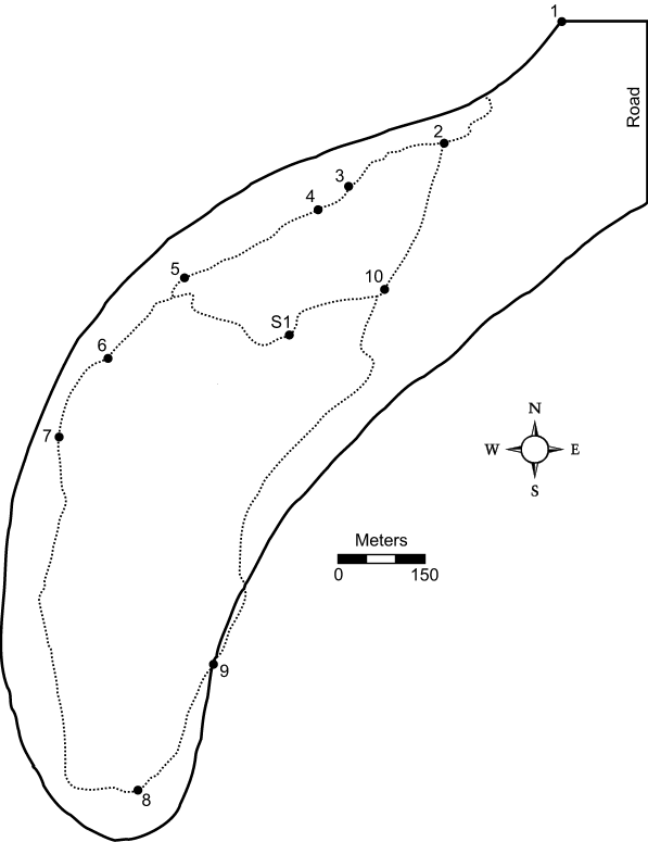
There are two routes available through Oxbow Woods:
Terrain varies from level to uneven ground. Fallen logs are a natural part of a forest, so please be cautious! Ground cover varies from tall grass, open forest to dense shrub. Young children should be accompanied by adults.
The stop numbers listed here coincide with the numbers indicated on the orange markers (see Appendix C). Follow the direction of the arrows and use the map to navigate, but if in doubt, continue on the most used deer trail.
| Stop 1: | This is the north meadow of the Oxbow forest. It is mainly comprised of snowberry, raspberry and grasses. To the west and south-east are the old channels of the river that are characterized by the marsh vegetation (cat-tails, bull-rush and reed grass). This area was grazed by cattle earlier this century and was accidentally burned in the spring of 1991. |
| Stop 2: | A transition is taking place from meadow to forest. You will notice the change in vegetation with the presence of treed patches that are interspersed with meadow. The shrubs are mainly cherry trees, hazelnut and cranberry. See if you can find some ant hills, deer scat or interesting birds along the way. |
| Stop 3: | Now that the meadow to forest transition has been made, notice the trees surrounding you and the different ground cover. The dominant trees here are green ash, bur oak, Manitoba maple and balsam poplar. The large tree behind the sign is different than any other tree around it. This basswood is the only one present, and it reaches its northern limit in this forest. Many of the dominant ground cover species have eastern deciduous forest affinities (e.g., tall cone flower and hog peanut). |
| Stop 4: | You are now between two large ostrich fern stands. Since these ferns are colonial the stands can be considered as two separate plants. Like the oaks, they seem to prefer the higher ground, whereas the ash and the maple prefer the lower areas. |
| Stop 5: | Look at the trees around you now. Many of the elms have died from Dutch Elm disease. A few of these American elms have survived and exist in this small patch in the forest. Many grasses have colonized where the canopy has opened up. |
| Stop S-1: | This is a predominantly green ash forest with almost a complete sedge ground cover. If you look carefully, you may see relict trembling aspens and an old deer blind up in an ash tree. |
| Stop 6: | You may notice that the forest is getting more closed in and shrubby. Hazelnut makes up most of the shrub layer in the heart of the forest, while saskatoon and cherry are found at the edge of the forest. The standing dead tree to the right has been well used by woodpeckers. Insects, mosses, fungi and other micro organisms break down the dead material in the forest. |
| Stop 7: | The distinctive grass species you will begin to see in this area is called bottle brush grass, which also has an eastern affinity. The fresh mounds of dirt you often see are from pocket gophers. Certain annual plant species seem to colonize on these rich, exposed areas. |
| Stop 8: | You may have noticed that the shrub layer is well developed in the south end of the forest. There are the greatest number of large oaks concentrated at this end as well. Lightning strikes are apparent throughout the woods. They will take out a single large oak or ash tree and sometimes start localized ground fires. |
| Stop 9: | The path leaves the forest here and goes through the ecotone between the marsh and the forest. Note, yet again, the transition from marsh to forest vegetation, and some of the distinct species only found on the edge of the woods (e.g., peachleaf willow). |
| Stop 10: | Perhaps the first thing you will notice of this stand of trees is the ghostly gray bark, or perhaps it is the distinctive sweet smell. It is the only pure stand of balsam poplar left in this forest. There are a few reasons why it may be here. By looking around, can you think of any? |
If you follow the trail across the meadow, you should come to Stop 2 on the right. This trail will return you to the starting point at the north meadow.